Tracking and telemetry
To ascertain where the launcher is and what its operating status is during flight, tracking radars and telemetry antennas track it at all times.
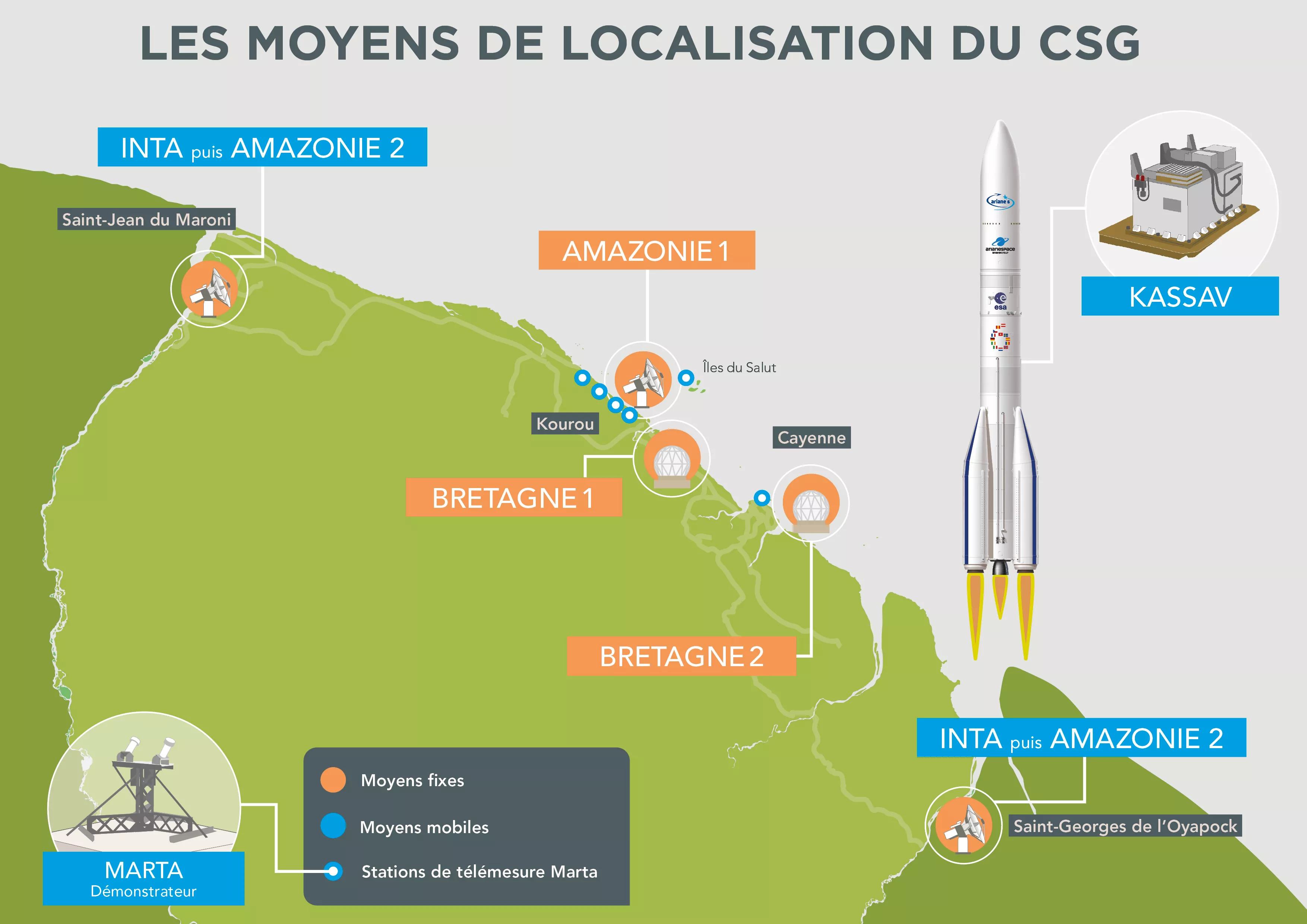
At Europe’s spaceport, the tracking teams are responsible for monitoring the launchers from lift-off until the satellites are placed into orbit. Using the four radars and telemetry antennas at Europe’s spaceport, relayed by a global network of tracking stations, flight data is collected and analysed in real time to ensure that the launch goes smoothly.
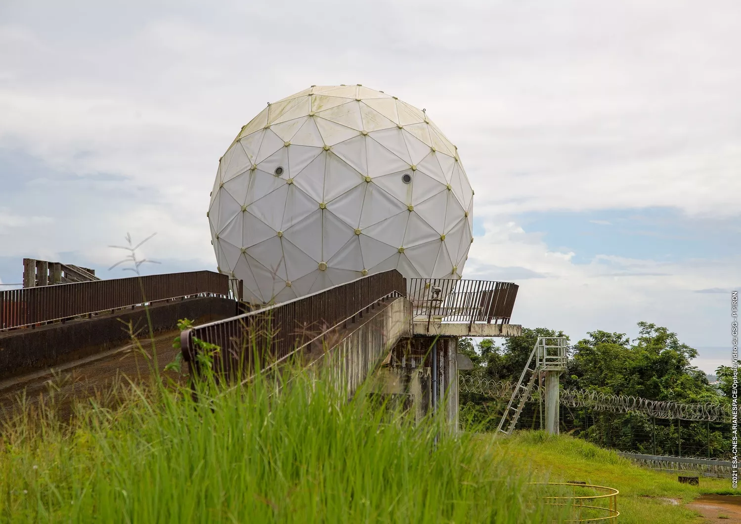
The Galliot tracking station on the Montagne des Pères in Kourou.
Ensuring that the launcher is on course: tracking radars
Ascertaining the exact position of a launcher during flight and its operating status is essential in guaranteeing the protection of people, the environment and property. If a launcher were not to follow the planned trajectory, it would have to be neutralised to avoid ground impacts.
At Europe’s spaceport, ground-based radars are the primary means of tracking used and play a crucial role in launch operations: They monitor the launcher from lift-off for about 10 minutes, depending on the mission and type of launcher. After this point, a launcher is no longer a danger.
How does a radar work?
A radar determines the position of a target by transmitting radio waves and measuring the time it takes for these waves to return after being reflected by the target. The distance is calculated based on this travel time, and the direction based on the position of the antenna that picked up the echo.
Each launcher is equipped with two radar transponders, positioned on the core stage of the launcher. The signals transmitted by these transponders and picked up by the radar assure us that the object being tracked is the launcher, and not a booster that has already separated.
During a launch, all the radars are synchronised and activated at Europe’s spaceport to interrogate the launcher one after another.
Technology that stands the test of time
While the Amazonie radar is new, its predecessors, Bretagne 1 and 2, are over 60 years old.
This very old equipment is regularly maintained and remains mechanically highly efficient, with accuracy levels 10 times greater than those of telemetry receiving antennas.
Titre brut
Bretagne 1
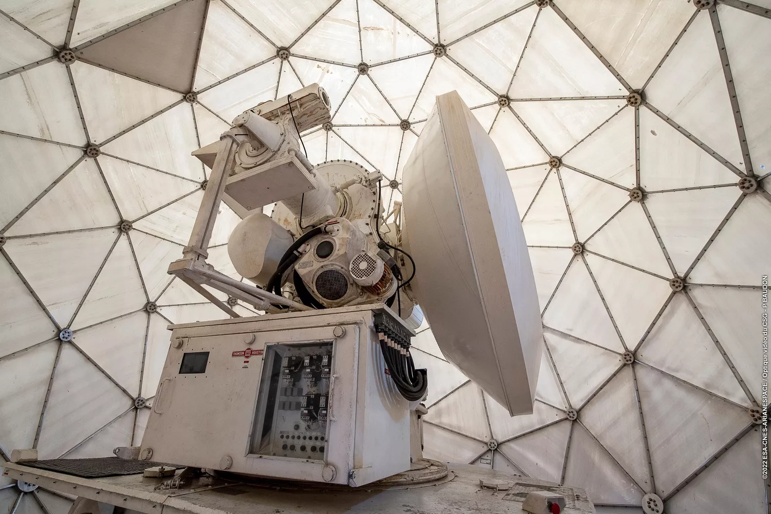
The Bretagne 1 radar, installed in French Guiana in 1967 on the Montagne des Pères in Kourou, is more accurate than a Swiss watch thanks to its high-precision mechanical gears. It takes 585 measurements per second.
It can generate an electromagnetic wave with a power of 1 megawatt through its 3-m diameter antenna. Its mission begins as soon as the launcher lifts off.
Titre brut
Bretagne 2
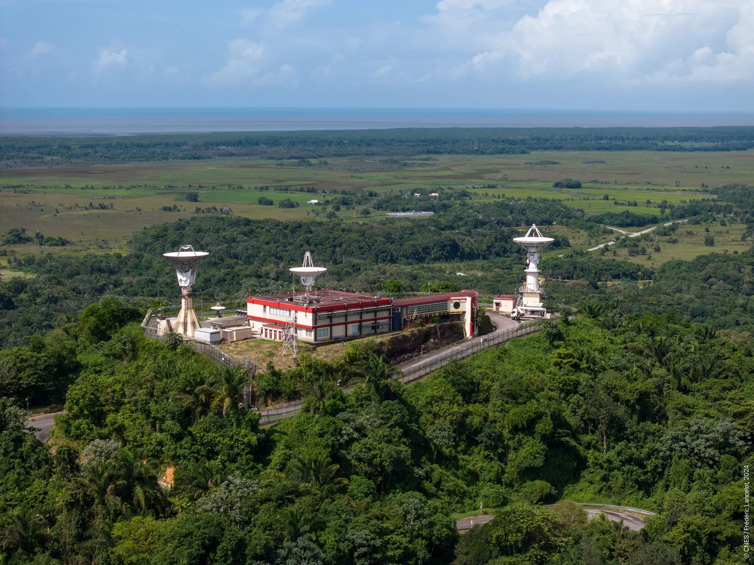
The Bretagne 2 radar, installed at Europe’s spaceport in 1970, is located on the Montabo hill in Cayenne. Like its twin, Bretagne 1, it can track the launcher as soon as it lifts off from the launch pad.
Titre brut
Amazonie 1
The Amazonie 1 radar, installed in 2020 and qualified in 2021, is located on the Pariacabo hill in Kourou, next to the Ibis observation site. It is a latest-generation radar that can even be operated remotely.
Titre brut
INTA
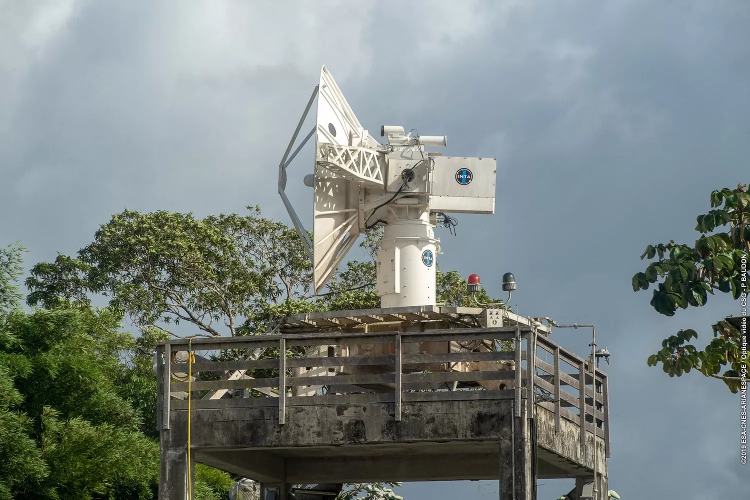
The INTA radar, leased from the Spanish space agency, is used for Vega-C launches to avoid the effects of flames caused by the solid propellant combustion gases. This radar is positioned to flank the trajectory either to the north-west of French Guiana, in Saint-Jean du Maroni for launches to the north, or to the east, in Saint-Georges de l'Oyapock for launches to the east. Its performance is similar to that of the Bretagne radars.
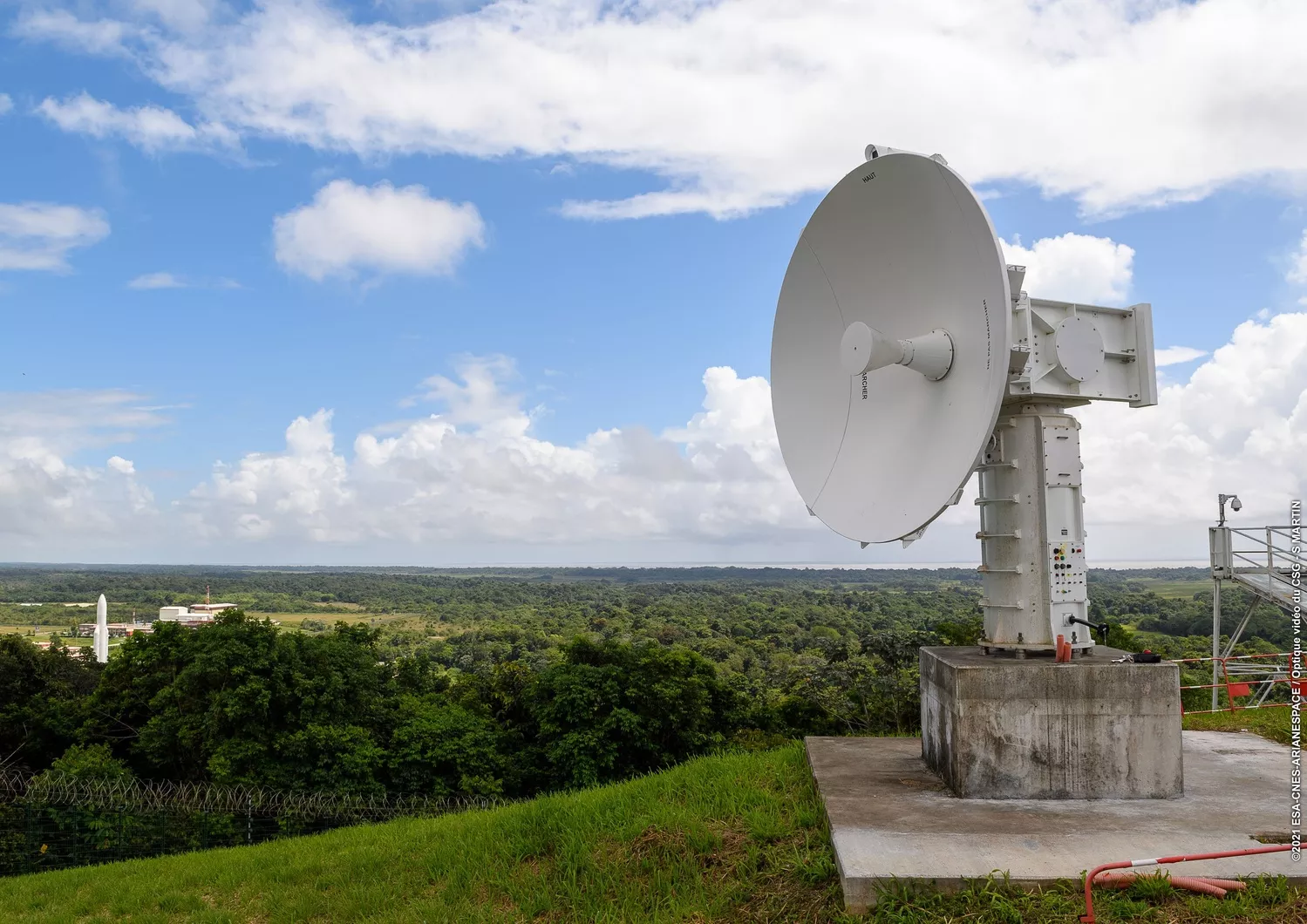
Ensuring the launcher’s health: telemetry antennas
Speed, position, altitude, propulsion data, pressure, temperature, vibrations, voltages, currents, and more. With over a thousand parameters measured, the telemetry antennas receive vital data from Ariane 6 or Vega-C. When the radars in French Guiana can no longer see the rocket, the telemetry antennas become indispensable. They alone can confirm that the launcher and its passenger(s) are in good condition and on the right course, but also that it is executing its propulsion phases as planned. Finally, the telemetry antennas confirm the success of the mission.
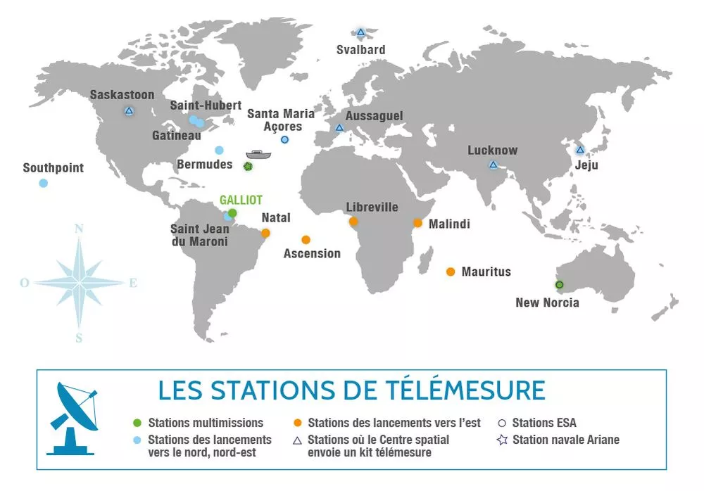
The network of telemetry stations begins on the Montagne des Pères, around 30 km from the launch sites. Located under the trajectory of the launchers – from French Guiana to Africa, via Brazil and the Atlantic Ocean – the antennas take turns to track the launcher in real time until the end of its mission. Data on the position and behaviour of the launcher is processed instantaneously and displayed on the monitors in the Jupiter Control Centre. Without an antenna, the teams in charge of tracking the launchers would be blind and deaf!
Depending on the satellite’s mission and the orbit into which it is to be injected, the launcher’s trajectory may be oriented to the east or the north and north-east.
For launches to the north and north-east, potentially useful stations are chosen according to their availability. In view of the technical preparations as well as international agreements, the setting up of the network of stations must be planned one year ahead.
In addition to taking measurements, the telemetry antennas are able to see the different phases of a launch.
For example, this is what the stations can see for an Ariane 6 launch to the east:
• Galliot (in Kourou, French Guiana): sees the lift-off, the burnout and jettisoning of the boosters. The station tracks the launcher for about ten minutes.
• Natal (in Brazil): sees the end of propulsion of the main stage and the ignition of the upper stage.
• Ascension (island in the south of the Atlantic Ocean): Receives information on the launcher’s speed, temperature, vibration, etc.
• Libreville (in Gabon, Africa): sees the end of propulsion of the launcher’s third stage and tracks it for about 10 minutes.
• Malindi (in Kenya, Africa): sees the separation of the satellites, their injection into orbit and the end of the launcher’s mission.
This is what the telemetry stations see during a Vega-C launch to the north:
• Galliot (in Kourou, French Guiana) and INTA (in St Jean de Maroni, French Guiana): see the lift-off, the burnout and jettisoning of the first stage, as well as the ignition of the Zefiro 40 engine and the separation of the second stage. The two antennas track the launcher for about ten minutes.
• Bermuda (in the Atlantic Ocean): sees the separation of the fairing, the ignition and the separation of Zefiro 9 engine.
• Gatineau (Canada): sees the ignition of the upper stage with the fairing containing the satellites.
• New Norcia (Australia): sees the second ignition of the upper stage and the separation of the satellites once it has reached the required orbit.
• Bermuda: sees the re-ignition of the upper stage for the third time over Cuba, in order to re-enter the atmosphere and avoid leaving debris in orbit.
During a launch with a specific launcher trajectory, two other telemetry stations can be used: Lucknow in India and Jeju in South Korea.
Complementary systems
Kassav (autonomous kit for flight safety)
The Kassav geolocation system, which complements ground-based equipment, is carried on-board the Ariane 6 launcher. It is composed of two devices: a GNSS (Global Navigation Satellite System) receiver and an inertial measurement unit*, which track the launcher accurately and reliably. The device, as big as a car battery, is a feat of pure precision, capable of continuously calculating the position of the launcher during flight and sending the information back to the ground via a dedicated telemetry system. Autonomous, it is fitted with long-life batteries and can operate even if the satellite link is lost.
* An inertial measurement unit is a navigation system that provides the orientation of a body in 3D space.
Marta (Multiple antennas for trajectory acquisition)
This system is made up of six small telemetry stations and a central server, and has to provide a new measurement of the launcher’s location for flight safety.
The principle is simple: the MARTA network of stations triangulates the telemetry transmitter on-board the launcher.
In particular, this system can locate reusable launchers such as Callisto.
Cinetelescope
On Île Royale in the Salvation Islands, the French Space Agency has a building housing an old cinetheodolite under a dome. It was installed in 1968 and converted into a cinetelescope in 1995. Activated for launches to the north, this instrument tracks and films the entire flight phase, from lift-off until the launcher is no longer visible.
Data processing
During the launch, all the data received by the tracking systems is processed by the Coordination, Processing and Display System (SCTV). Its role is to ensure the simultaneous execution of the expected operations, but also to provide live measured data to the teams supervising the launch. The information gathered by the tracking system is a key element in the decision-making process of the Safety department responsible for the safety of people and property.
After launch, the SCTV draws up reports and measurements based on the data received and processed throughout the flight. This information is used to validate the success of the launch or to investigate and rectify any malfunctions detected before the next launch. The aim is to achieve near 100% reliability for European launchers.