Antennas and radars

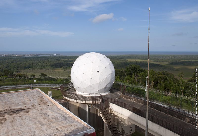
The Galliot tracking station, at the top of the Montagne des Pères in Kourou
Knowing where a launcher is during flight and its operational status are essential for the safety of people, the environment and property. It must be possible to intervene in case of a problem. Thus, antennas and radar track all launches from the Guiana Space Centre.
Ensuring that the launcher is on course: radar
In French Guiana, three main radar units are responsible for tracking the launcher to check that it is correctly following its trajectory, from lift-off to a distance of 1,500 kilometres. This is the function of the Bretagne-1 radar, located on the Montagne des Pères, immediately after lift-off. However, redundancy is essential to correct any failures. It is the Adour-2 radar - now at the end of its life - which plays this role for Bretagne-1: located at the GSC weather station, it is also activated at each launch. Finally, the Bretagne-2 radar on top of Montabo Hill in Cayenne takes over about 80 seconds after the launcher has lifted off.
Modernising the equipment
Intended to replace Adour-2, the Amazonie 1 radar, installed on the Pariacabo hill in Kourou, was qualified at the end of 2021. The next step was the renovation of Bretagne-2 and Bretagne-1, which are more than 50 years old. Once this renovation has been completed, Adour-2 will be dismantled. Finally, the Amazonie 2 radar will complete the system in 2025.
Two complementary systems are used reinforce the tracking systems:
Kassav (Kit Autonome comme Solution de SAuvegarde en Vol, Autonomous Kit as In-Flight Backup Solution), a tracking system onboard Ariane 5, and Marta, an experimental demonstrator consisting of six small telemetry stations that track the launcher by triangulation.
To find out more: see the What’s new in tracking and the Map of GSC’s tracking equipment
Virtual tour of the station on the Montagne des Pères and on Montabo Hill
Checking the launcher’s health: telemetry
Speed, position, altitude, propulsion data, pressure, temperature, vibrations, voltages, currents, and more. With over 1,500 parameters measured, the telemetry antennas receive vital data from the launcher. When the radar in French Guiana can no longer see the launcher, the telemetry antennas become essential. They alone can confirm that the launcher and its passenger(s) are in good condition and on the right trajectory, but also that it is performing its propulsion phases as planned. Finally, it is the telemetry antennas that confirm the success of the mission.
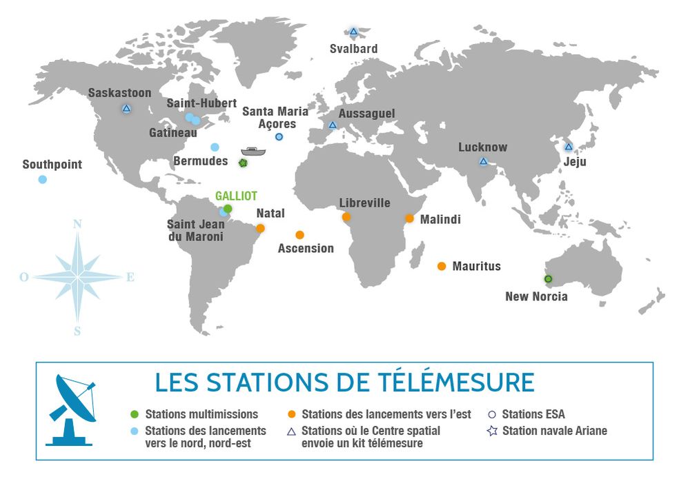
In order to fully track all launches from French Guiana, a network of telemetry stations has been developed across the globe.
For launches to the north and north-east, apart from Galliot, the other potentially useful stations are chosen according to their availability. In view of the technical preparations as well as international agreements, the setting up of the network of stations must be planned one year ahead.
Located on the Montagne des Pères, in Kourou, the Galliot station is the first station to track all the launches, both to the north and to the east.
See the different stages of the launcher during flight
In addition to taking measurements, the telemetry antennas are able to see the different phases of a launch. For example, this is what the stations can see for an Ariane 5 launch to the east:
Galliot
Natal
Ascension
Libreville
Malindi
Sees the lift-off, the burnout and jettisoning of the boosters. The station tracks the launcher for about ten minutes.
Sees the end of propulsion of the launcher’s main stage and the ignition of the upper stage.
Receives information on the launcher's speed, temperature, vibration, etc.
Sees the end of propulsion of the launcher’s 3rd stage. It tracks Ariane 5 for about 15 minutes.
Sees the separation of the satellites, their injection into orbit and the end of the launcher’s mission.
Using extensive computer equipment available at all telemetry stations, data is recorded and sent back in real time to the telemetry evaluation system (SET) at the Galliot station. The SET centralises and processes the information and distributes it to the various teams supervising the launch: CNES, Arianespace, and the telemetry manager.
Tracking the launchers from the Salvation Islands
Another piece of equipment, located on Ile Royale in the Salvation Islands, is used to view and film the entire flight phase of a launch towards the north until the launcher soars out of sight - this is the Cinetelescope.

Antennas and radars from west to east
The power of Vega’s engine blinds the antennas installed in Kourou. For the flights of this launcher, and depending on its trajectory, antennas and a mobile flanking radar, INTA, are moved to the west of French Guiana to Saint-Jean du Maroni, or sometimes to the east to Saint-Georges de l’Oyapock. From 2025, the Amazonie 2 radar will replace INTA, which has been leased to a Spanish company.
To find out more about the Saint-Jean du Maroni station.